Walks In Durrow
The walks pages on Walking Durrow aim to provide you with a detailed route map, plus elevation details and a 3D Flyover video of each walk.
Using The Route Maps
The map of the sample walk below, which is a basic loop walk around Durrow village, has a horizontal blue line beneath it. If you place your cursor in this area, a thin vertical line appears.
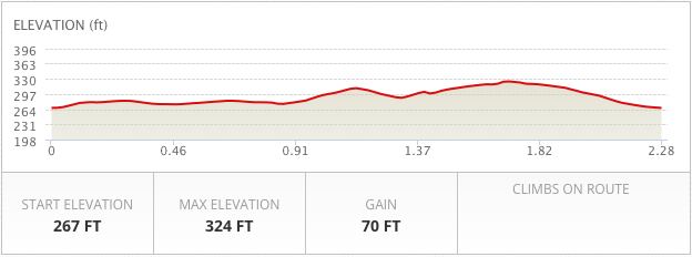
This vertical guide works in tandem with both the route map above and the elevation chart below. As you drag the vertical you will see the marker move along the route map, and the distance in metres, and the elevation charts below the vertical, also correspond to the point displayed on the map.
Village Loop
Map Options
By default the maps appear in Satellite mode, but if you click the drop down symbol in the top right hand corner of the map, you can change the viewing mode.
Fullscreen
The fullscreen option is also in the top right corner of the map. It is the symbol to the left of the viewing mode.
Panning and Zooming
To pan the map you can use the panning wheel, which is located in the top left hand corner or alternatively click and hold, on the map and drag.
To zoom in on an area of the map, use the Plus & Minus slider, which is located on the left hand side of the map.
Street View
To activate the Street View option on the maps, simply drag the orange person symbol, and place it on the area of the map you wish to view.